
3D Laser Scanning
with Point Clouds
We capture the existing conditions of buildings, industrial plants and facilities using 3D laser scanning (terrestrial LiDAR), so you can measure, design and coordinate your projects using an accurate point cloud.
This is our flagship service
The one we enjoy the most
If we could only keep one, it would be this one
If you want to learn more about this topic, keep scrolling down this page
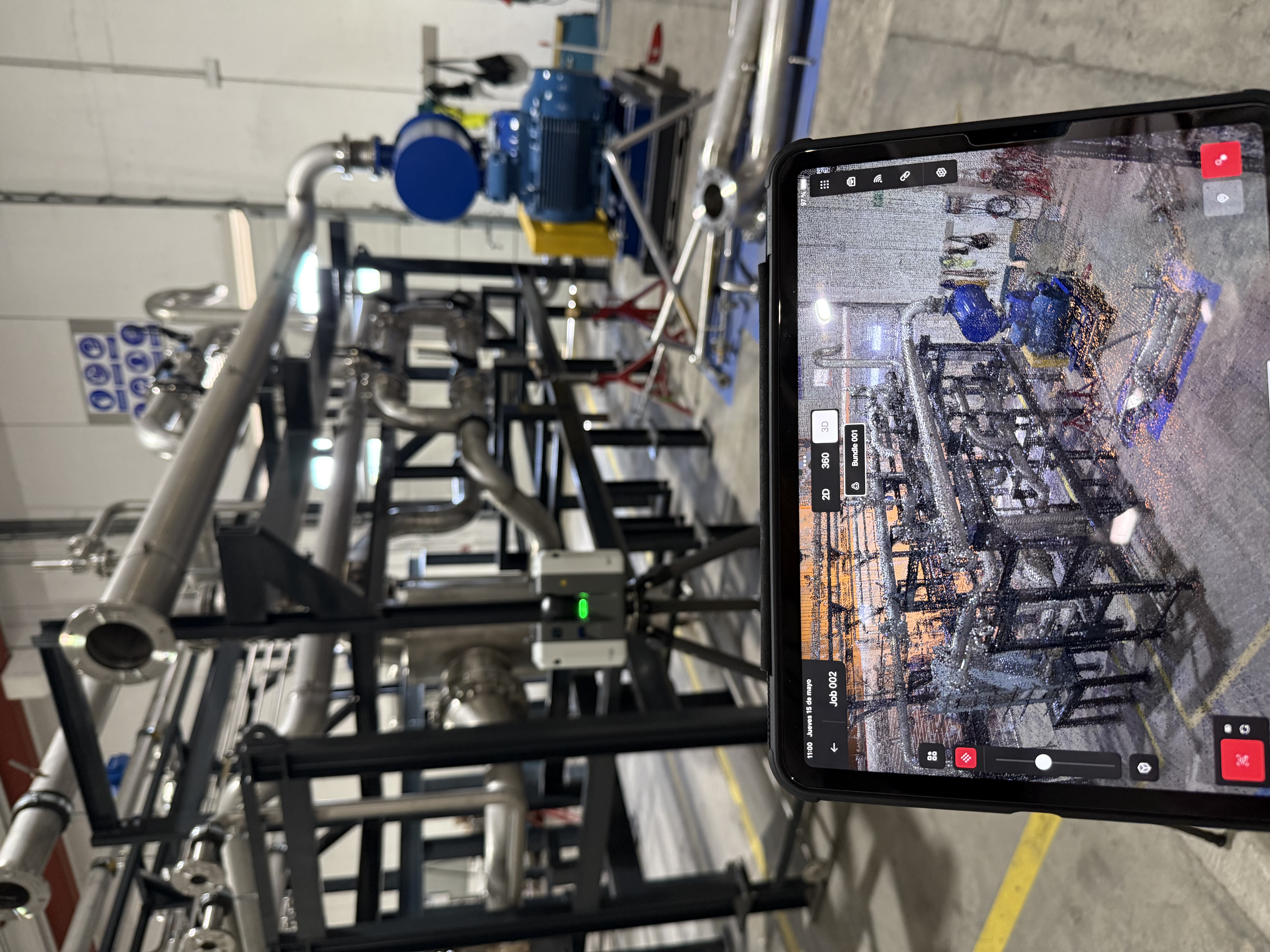
What is a point cloud (explained for humans)
You've probably already heard about point clouds if you've made it this far.
But if that's not the case, and you've never seen one, we'll explain it in a very simple way so anyone can understand.
Even if you have to explain it to your boss to get the investment approved.
You'll be able to explain it to that person who still works with hand-drawn plans.
When you do a 3D Laser Scan, the scanner shoots a laser in all directions and leaves points wherever it touches. The set of points makes it a point cloud.
Look around you right now. What's around you. What your eyes see.
Yes, at this very moment.
Now imagine you can move your head in all directions like the girl from the exorcist.
Everything you see is what you'd see in the point cloud if you were a scanner.
For the point cloud to also show what you don't see, you must move the scanner to places where those things can be seen.
To the next room, behind that object…
And the result is something like this
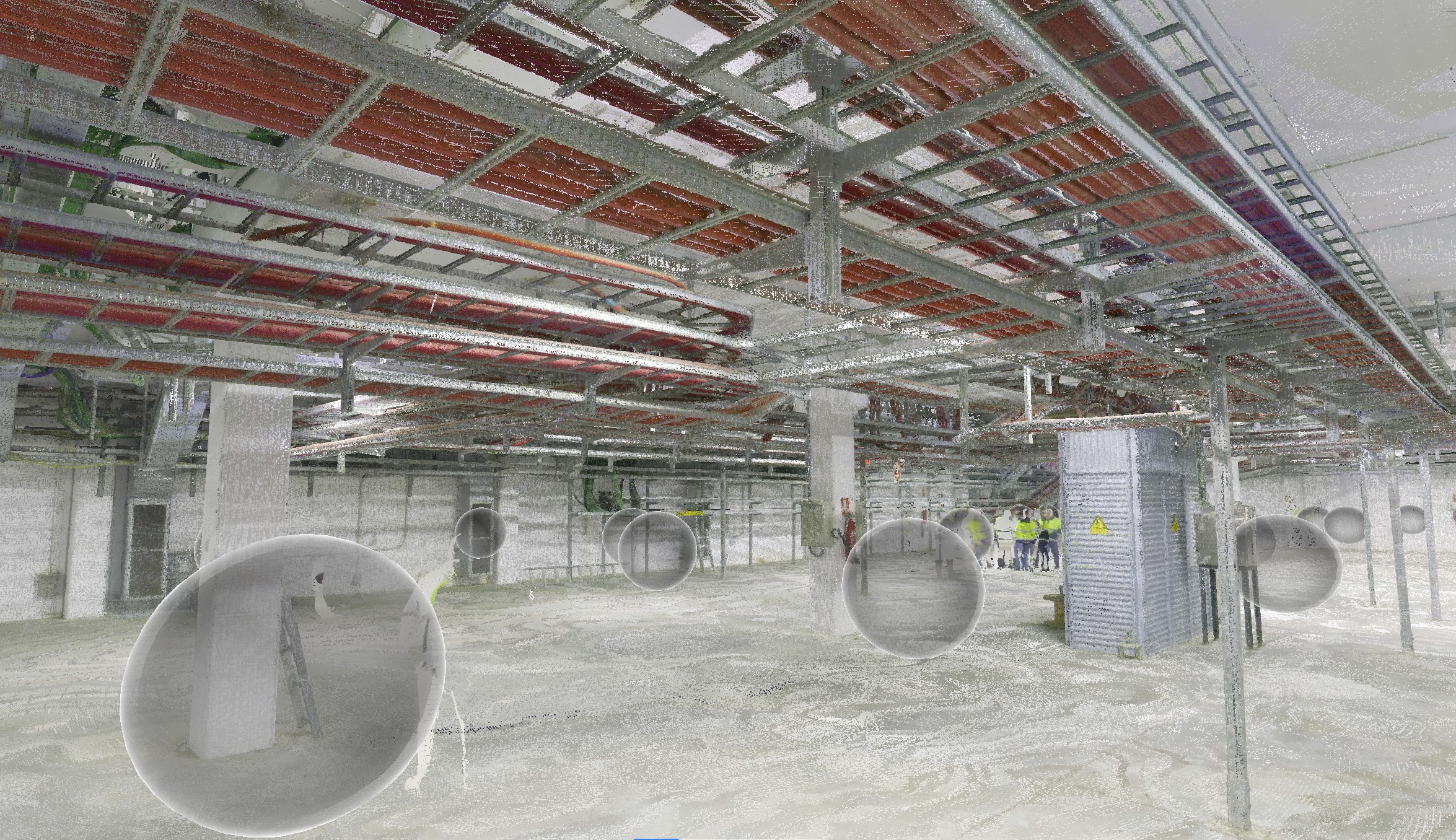
In addition to the point cloud, the scanner takes a 360 photo at each point where you scan.
Those photos transport you to the site.
They allow you to take measurements clearly directly in the photo.
The point cloud is the file that you'll later put in your design software: Revit, Plant3D, AutoCAD, Inventor, SolidWorks.
And so you'll do the project within the real environment that will help you not forget things and ensure that what you decide won't create unexpected problems on site later.
If your project involves a factory or process facility, explore our industrial 3D laser scanning for process plants service.
If you've understood this, it will be even easier for you to understand how we work.
This is how we work at BIMCOTECH
First of all, we listen to you when you tell us about your project.
We make sure to understand which points are key for you, where you need a high level of detail.
For example, there are projects where you need to have clarity and precision on the start and end points of conveyor belts. There are others where you need to know where the equipment piping is to design the pipes that connect. And others where you need to have the exact space to know where to place a machine and how to get it in. Or there are even some where you need to know the exact location of pillars or the slope of the floor.
Then we go to the field.
Wherever your project is.
Like this past year when we went to an industrial plant that's 5 hours by car from Prague in the middle of December, to a building in downtown Alicante in August, or to a factory in Portugal.
Wherever you have it
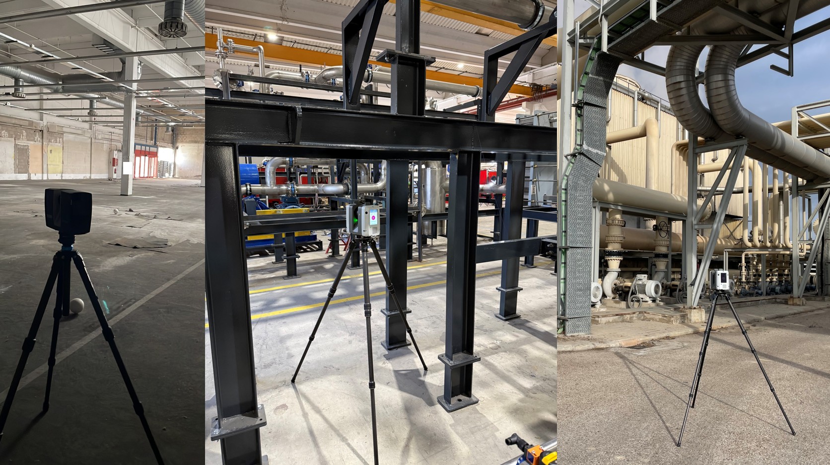
Once there, we scan every 5 meters in general, and in more detail at those points you've told us are critical for you.
Once the project is finished, we return to our office, process the cloud, clean it so you can use it comfortably on your computer, place it in your project coordinates, and send it to you.
Notice we wrote "send" instead of "deliver".
That has a reason. And it's that our commitment to you hasn't ended yet.
At that moment is when we verify that you've been able to open it on your computer.
And that you've incorporated it into your workflow.
We give all new clients free training.
Training on point cloud visualization. So you can get the full benefit from it.
Free training for new clients
We give all new clients free training so they can visualize the point cloud without problems from day one.
So you can get the full benefit from it.
It's our way of working, neither better nor worse. It's ours.
But we live more peacefully if you don't call us because you've had problems opening the cloud or don't know how to use it.
Just as you live more peacefully if the installer doesn't call you and tell you that what you've designed can't be done because there's a beam you didn't consider.
That peace of mind, that happiness, comes from doing a point cloud before starting the project.
It could be others or it could be us, but find someone who understands your project and who helps you use the point cloud they deliver.
We're simple and time is what we value most.
That's why we work fast, and that's why we don't make you wait.
If you have a project in mind, right now you can make a quote yourself.
Pricing (no "it depends")
We scan 1,000m2 for €1,250 + travel expenses if outside Catalonia
That's the minimum price
For the surface area, you must count all existing surfaces. If it's a 4-story building of 500m2, that's 2,000m2
We only accept consistent clients, just as you pay and only want collaborators who deliver what they said they would.
If those numbers work for you or you simply can't figure it out, we'll be happy to help you at info@bimcotech.com and we'll make you a quote instantly.
No beating around the bush and no "it depends", "let me see if I have availability" and those things you've sometimes heard.
Once you have the point cloud, if you want more, we have other very valuable services that will help you go faster:
As-built Modeling
If you ask us to model everything, Joan will be delighted with the order amount, but read carefully: Normally it's not necessary to model everything. We model the elements that are necessary so you can then extract the 2D plans. And everything else you already have in the cloud. And we teach you to work that way
Modeling Training
If you want to be totally independent when we deliver the point cloud, we teach you to model any element that appears in it. Both in AutoCAD, Revit or Plant3D.
If you don't know how to use the point cloud to do your projects in 3D, we explain to you in a fast, clear and simple way, exactly the clicks you need to make. This training is 100% adapted to your case. We don't do 2 trainings alike. We don't come to tell you that you're doing things wrong. That would be arrogance beyond normal. Your company bills and your company is doing well. You're clear on what works and what doesn't. With the trainings we tackle the aspects where you can go faster adapting it to your internal workflows. And that will make you improve and save you many headaches.
3D Laser Scanning and Point Cloud Training
This training is very special to me.
It's not for everyone. It will only be useful if you're really going to scan yourself.
Only if in your company you're going to integrate the scanner in all your projects.
Or if you're going to set up a scanning department or if you're going to create a point cloud company.
It's only for scanning spaces, facilities. It's not for scanning parts. This is important.
In this training I explain all my experience in 10 years of scanning. How to scan. How to process. When to buy and when to rent. At what price to sell. Where to find clients. How to sell them the service. What happens when you scan abroad.
I explain everything I know.
And you'll ask yourself, how can this guy teach me everything he knows if I'm going to compete with him?
That's what I asked myself the first time they asked me for this training. When I didn't even know what to explain yet
There are so many plants, buildings, factories, spaces to scan.
I still arrive at industrial plants where the engineering director doesn't know that projects are now done in 3D. So imagine how many clients are still out there.
I'm not going to reach everyone, but what I'm sure of is that the more people dedicate themselves to this, the more knowledge there will be about it, and therefore, the more demand we'll all have.
Frequently asked questions about 3D laser scanning
How much does a 3D laser scan cost?
We scan 1,000 m² for €1,250 + VAT, plus travel costs if the job is outside Catalonia. This is the minimum price. To calculate the area, add up all floors: a 4-storey building with 500 m² per floor is 2,000 m². If you are unsure about the area, write to us and we will prepare a quote.
What is the difference between a 3D laser scanner and LiDAR?
In practice they are two ways of naming the same thing. LiDAR (Light Detection and Ranging) is the technology that measures distance with laser light, and the terrestrial 3D laser scanner is the instrument that applies it from fixed positions to capture millions of points of a building or facility. The result is a point cloud on which you model and design.
How long does delivery of the point cloud take?
The usual delivery time for the point cloud is 3 days after the on-site scan. On large projects we deliver in stages, so you do not have to wait for all the work to finish before you start using it. The exact timeline depends on the area, complexity and access, and we agree it after reviewing your project. As an indicative reference, we capture roughly 1,000 m² per day, depending on density, access and obstacles.
How accurate is the point cloud?
We work with the Leica RTC360 and RTC500, with a nominal accuracy of 1.5 mm at 10 m. This is an equipment specification, not a guarantee of accuracy for the complete survey. With our method of scanning every 5 m, the overall accuracy of the cloud, where there is no vegetation, is around 5 mm. Before we start, we define with you which areas need more detail and we scan the critical points at higher density.
What does the scanning service include?
We scan on site, generally every 5 metres and in more detail at critical points. We then process and clean the cloud, place it in your project coordinates or in survey coordinates, and send it to you with the 360° photos from each scan position. We check that you can open it, and we give new clients a free training session on how to view it.
What formats do you deliver the point cloud in?
We can prepare RCP/RCS, E57 or LGS/LGSx depending on the target software, such as Revit, AutoCAD Plant 3D, AutoCAD, Inventor or SolidWorks. We confirm format and compatibility before we start.
Do you need to model the entire point cloud?
No. Usually it is enough to model the elements needed to produce 2D drawings or that could interfere with the new installations, and you already have everything else in the cloud. If you would like us to do it, see our As-Built Modeling in Revit, Plant 3D and AutoCAD service.
Do you work outside Barcelona and Catalonia?
Yes. We carry out projects throughout Spain and travel to other countries in Europe. Tell us where the site is so we can confirm planning and travel conditions.
What information do you need to prepare a quote?
Project type, location, approximate area and deadline. If you have drawings, photos or other information, include it in the form message.
If you don't have any project yet where we can collaborate, I recommend you sign up for the newsletter where every day you'll receive value that you can surely apply to your day-to-day.
What does this guy talk about in his newsletter?Do you have a project that needs surveying?
Tell us what you need. We’ll assess your project with no obligation and prepare a technical and commercial proposal tailored to your requirements.
Thank you for contacting BIMCOTECH
We’ve received your project details. We’ll review them and get back to you as soon as possible.
We couldn’t send your request
Please try again or email us directly at info@bimcotech.com .