
Reality capture for engineering
Industrial 3D laser scanning
Before modifying a factory, you need to know what is actually there. We capture existing industrial plants and facilities with a 3D laser scanner (terrestrial LiDAR) so your team can design using a point cloud of the real environment.
For engineering teams and plant managers planning extensions, new equipment or As-Built documentation. We work with you to define what needs scanning and what information you need to receive.
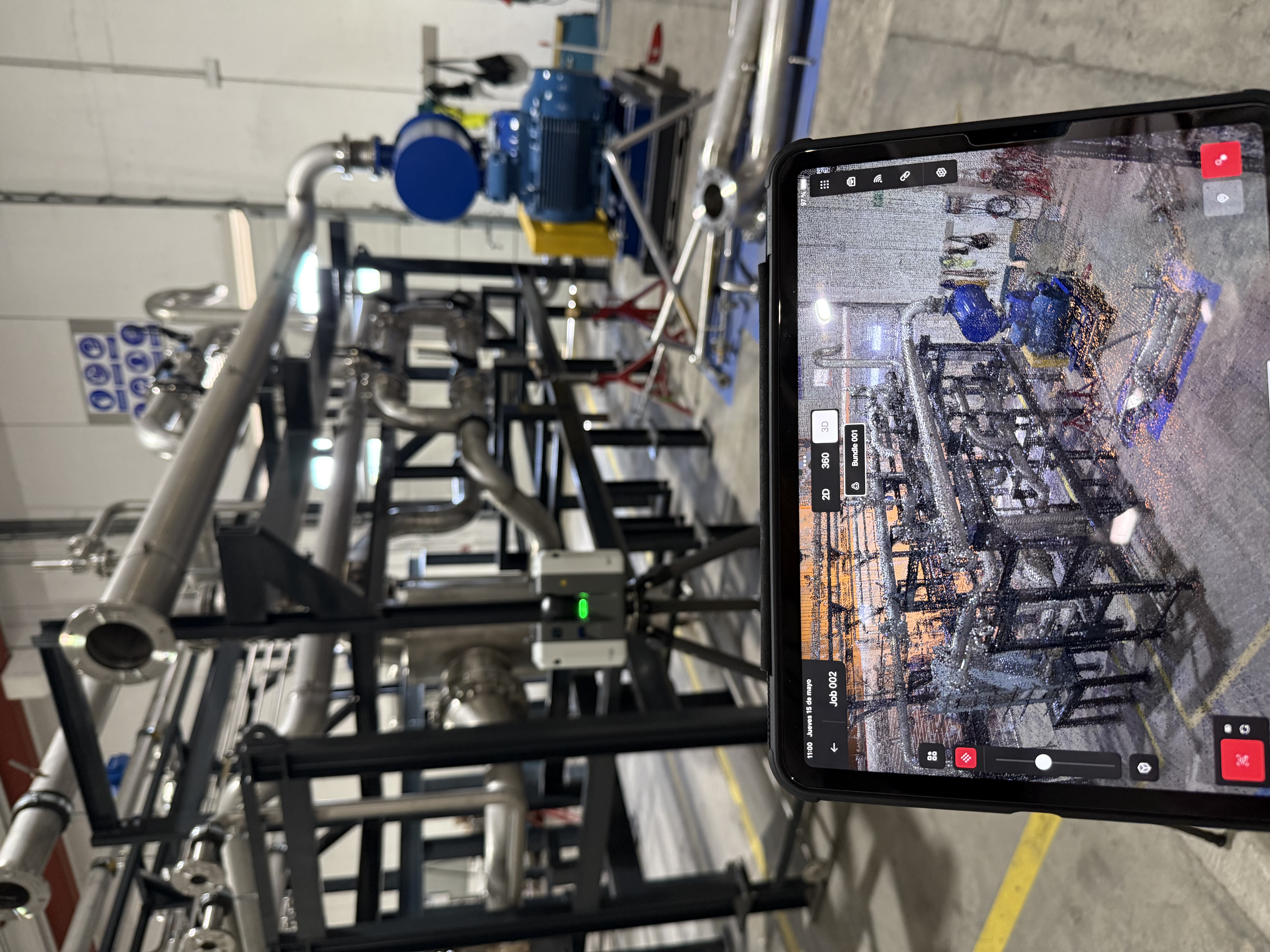
When the drawings no longer tell the whole story
A rerouted pipe, an added platform or a machine that has moved. Changes accumulate and the drawings stop reflecting the facility. If the design is based on that information, the questions arise when installation begins.
Laser scanning lets you review geometry and check available space without relying solely on individual measurements. The point cloud provides a reference for designing within the existing environment and checking potential clashes before work starts.
We define the areas of interest and visibility limitations: the scanner records surfaces visible from the scan positions, not what is hidden behind an enclosure.
What can you use the survey for?
- Plant extensions and modifications: check how the proposed work connects to the existing installation.
- Machinery installation or replacement: review available space, access routes and elements near the new equipment.
- Piping and installation modifications: use a geometric reference of piping, equipment and structures to coordinate the design and check connection points.
- Revamping: plan changes to facilities that have evolved over the years.
- Layouts and As-Built documentation: update the project reference with the captured conditions.
- Coordination and clash detection: check the proposal against the point cloud and, where appropriate, a model of the existing conditions.
Receive data you can use in your project
Point clouds and visual access
The main deliverable is a registered, cleaned point cloud ready to work with.
- Agreed formats: RCP/RCS, E57 or LGS/LGSx to suit your software and project requirements.
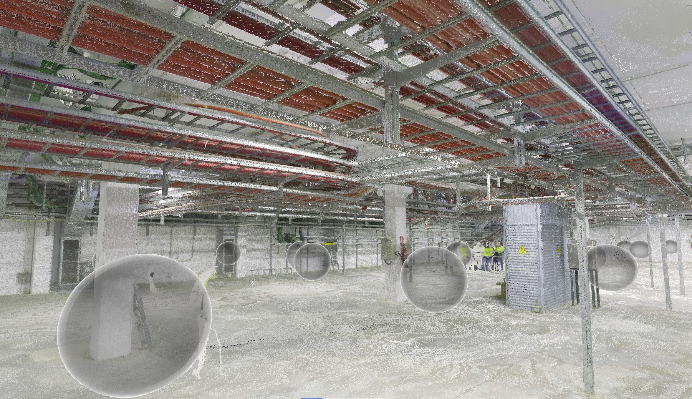
- Visual access: 360° photographs at each scan station to help you explore the facility. Where appropriate, we include a viewer.
- References: project coordinates or UTM positioning when required, with the references agreed before capture.
- Files by area: files split by area where necessary to make them easier to use.
Follow-on modelling, where it adds value
If you need drawings or editable geometry, we can quote for As-Built modelling in Revit, AutoCAD Plant 3D and AutoCAD. We define which equipment, piping or structures will be modelled and at what level of detail. The remaining elements can still be viewed in the point cloud.
The quotation specifies formats, scope, references and deliverables. Not every project needs the same set of files.
Visual example of a point cloud
From scope to delivery, with every step defined
- Scope definition. We review the purpose, areas, access arrangements and deliverables with your team. We identify critical areas and agree on the accuracy and point density needed for the project objective.
- On-site capture. We plan scan positions and coordinate the work around operations and conditions at the facility. Scan stations are usually up to 6 metres apart, with spacing adapted to critical areas, obstacles and potential occlusions.
- Registration and processing. We combine the scans and prepare the data for use.
- Quality control. We review registration consistency and coverage against the agreed scope, identifying any limitations found.
- Delivery. We supply the agreed files and the guidance needed to open and use them.
- Optional As-Built modelling. We turn the specified elements into the model or documentation your project needs.
A scope tailored to each industrial environment
The service can be used for process plants, chemical and food manufacturing facilities, factories and production sites, technical rooms, and logistics and energy facilities.
Each environment has its own restrictions. Before confirming the capture, we review access, permits and working conditions with the person responsible for the facility. The proposal needs to fit the plant, not the other way round.
Projects in Barcelona, Spain and Europe
We work in Barcelona and Catalonia and travel to carry out projects throughout Spain and Europe. Include the facility location in your enquiry so we can plan access, travel and the scope of work.
Complete the documentation your engineering team needs
If you also need to update your process diagrams, see our P&ID digitisation service. Captured geometry and process information serve different purposes, and both should be defined.
For other building types or applications, explore our general 3D laser scanning and point cloud service or see our complementary engineering services (in Spanish).
What do you need to modify or document at your plant?
Tell us what you need. We will review your requirements without obligation and prepare a tailored technical and commercial proposal.
Thank you for contacting BIMCOTECH
We have received your project information. We will review it and get in touch as soon as possible.
We couldn’t send your request
Please try again or email us directly at info@bimcotech.com .
Frequently asked questions about industrial laser scanning
How accurate is industrial 3D laser scanning?
The required accuracy depends on how the data will be used: preparing a layout has different requirements from checking equipment fit. We review distances, geometry, accessibility and control references to agree on the survey requirements. We use the Leica RTC360 and RTC500, with a nominal accuracy of 1.5 mm at 10 m. This is an equipment specification, not a guarantee of accuracy for the complete survey.
What is the difference between a 3D laser scanner and LiDAR?
In practice, the terms are used interchangeably when scanning industrial facilities. LiDAR is the measurement technology that uses laser light; the terrestrial 3D laser scanner is the instrument that applies it to capture millions of points with high accuracy from fixed stations. The result is a point cloud you can work with in Revit, Plant 3D, AutoCAD or Navisworks.
Does production need to stop?
We review this with the plant manager. Capture must be coordinated with access arrangements, equipment movements and safety conditions. Some areas may require a dedicated work window or a shutdown; we do not promise to scan every facility while it is operating.
What information do you need to prepare a quote?
The location, approximate area, zones and elements to capture, project purpose and deliverables. Also indicate site access arrangements, working hours and plant restrictions. If you have drawings, photographs or other information, mention them in your message so we can define the scope.
Which point cloud formats can you deliver?
We can prepare RCP/RCS, E57 or LGS/LGSx files to suit the target software and agreed scope. The 360° photographs at each scan station help you explore the facility; a viewer is included where appropriate. We confirm formats and compatibility before work begins.
Can you create an As-Built model in Revit or Plant 3D?
Yes. Follow-on modelling is quoted according to the required elements, the intended use of the model and the agreed level of detail. We can work in Revit or AutoCAD Plant 3D, or prepare other deliverables specified for your project. Modelling the entire plant is not always necessary.
Do you work outside Barcelona and Catalonia?
Yes. We carry out projects throughout Spain and also travel to other European countries. Tell us where the facility is located so we can confirm scheduling, access requirements and travel arrangements.
How long do scanning and delivery take?
The timescale depends on the area, complexity, accessibility and deliverables. As an indicative reference, our typical capture rate is approximately 1,000 m² per working day, depending on density, access, obstacles and scope. Capture and processing are separate stages; an As-Built model requires additional work. We agree on the schedule after reviewing the scope and available site access windows.